


MapIt GIS - GPS Data Collector


Description of MapIt GIS - GPS Data Collector
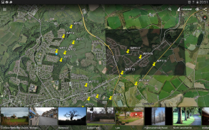
MapIt is a GIS app designed to support GPS data collection and any kind of GPS / GNSS based surveys. It's a mobile GIS tool for land and field surveyors and anyone dealing with environmental and GIS data. MapIt makes GIS data collection or field survey process faster and more efficient.
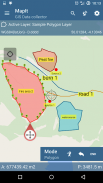
App can be also used as a measurement tool to calculate areas or distances.
The data can be organised on layers and exported to number of common formats.
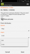
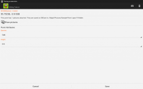
When registering location simply choose required attributes from defined drop-down list, no need to type the same information over and over again. Import long list of attributes from text files and re-use them in number of projects. If necessary you can add pictures to each location as well.
If you are working in the field, gathering large amount of spatial / location based data this app is designed for you.
MapIt is a perfect app for anyone involved in forestry, agriculture, environmental or farming business and allows quick collection of spatial data without the need of typing similar information number of times.
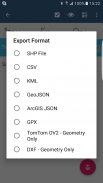
Speed up your workflow and make the data collection more efficient. Take advantage of survey layers and possibility to re-use same set of attributes for multiple surveys. Export your data to common GIS formats like Esri shapefiles, CSV, KML, GeoJSON, ArcGIS JSON, DXF, GPX and post process your data using Desktop GIS software like ArcGIS, ArcGIS Online or qGIS.
Please visit our website and follow a Walk-Through - http://mapit-gis.com to understand better the application workflow.
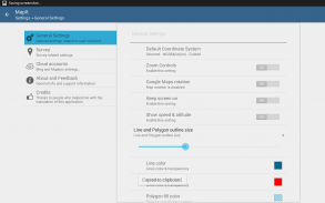
Support for number of coordinate systems: WGS84 (decimal or degrees), Web Mercator, British National Grid, UTM SAD69 (Brazil), UTM NAD83, NATO, Stereo 70 (Romania), System 1992 (Poland), UTM Indian 1975 (Thailand), SIRGAS 2000 UTM coordinate system for South & Latin America, ETRS89, TM06 – Portugal, D73 Modified Portuguese Grid or provide EPSG code if required.
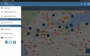
Mobile Data Collection Features:
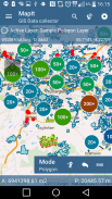
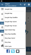
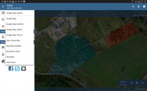
- Base maps: Google Maps, Bing Maps, Open Street Map, Mapbox and Offline mbtiles,
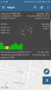
- Support for RTK corrected coordinates when external Bluetooth GPS / GNSS is connected,
- Support for WMS and ArcGIS Server Tiled map services as Google Maps Overlays (Load topographic and orthophoto maps, geological surveys, cadastral information and number of other services.
- Possibility to create and maintain sets of attributes - these are available as a drop down lists when new feature is being recorded, long lists of values can be imported from text files.
- Clusters for point map markers, efficient way of having large number of points on the map without performance issues,
- Currently 4 methods of collection are supported (GPS / GNSS location, Map cursor location, tracking, Point projection using angle and distance),
- Possibility to group your data into the survey layers - each survey layer may have a default set of attributes.
- Local SD card or remote export. At the moment Esri SHP files, KML, CSV, GeoJSON, ArcGIS JSON, GPX and DXF export is supported,
- Direct export to Dropbox or FTP location
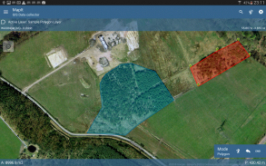
- Possibility to record multiple points, lines and polygons on one layer,
- When creating new polygon or line features measurement details like area or length are also available.
- GPS / GNSS and satellites status,
- Address, location search,
- Import point, line and polygon features into layer from CSV, KML, ESRI Shapefile or geojson file,
- Backup management,
- Import/Export attributes from file and much more to discover...
Our users are successfully using MapIt in number of applications including:
- environmental surveys,
- woodland surveys,
- forestry planning and woodland management surveys,
- agriculture and soils' types surveys,
- road constructions,
- land surveying,
- solar panels applications,
- roofing and fencing,
- tree surveys,
- GPS and GNSS surveying,
- site surveying and soil samples gathering
Do not hesitate to contact us directly or using the contact form on our website.</br></br></br></br></br></br></br></br></br></br></br></br></br></br></br></br></br></br></br></br></br></br></br></br></br></br></br></br></br></br></br></br></br></br></br></br></br></br></br></br></br></br></br></br></br></br></br>
MapIt GIS - GPS Data Collector - Version 7.8.0.0Core
(16-08-2021)

MapIt GIS - GPS Data Collector - APK Information
APK Version: 7.8.0.0CorePackage: com.osedok.gisdatacollectorLatest Version of MapIt GIS - GPS Data Collector
Other versions


Apps in the same category
You may also like...
 4.414.284.043.43


